
Apr 16, 2024
Apr 16, 2024
These Himalayan Rivers are pretty ancient. They have been there in some or other form since the times of rise of the Himalayas. Since then the region has undergone several climatic vicissitudes. There has been extreme glaciation for about 18000 years. Freezing temperatures, excess rainfall etc can have devastating effect on the rock surfaces. The slopes of the Alaknanda Valley are made of Phyllitic rocks which are loose and fissile. Such rocks are prone to landslides under heavy precipitation and extremes of climate. A landslide in such terrains means mass wasting in bulk and the muck slides down to the river. Many times it blocks the river temporarily from few days to several thousand years. Once the reservoir thus formed gets filled up and there is further pressure from the stored water, the unstable dam bursts, causing flash floods in its wake.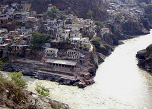 Alaknanda is a major tributary of the River Ganga. Alaknanda River from its source to confluence with the Bhagirathi River at Deoprayag flows through a sinuous course of 229 km. The two rivers after meeting at Deoprayag (Divine Confluence) form the mighty Ganga River. River courses have lots of tales in their courses. Geologists keep reading them from time to time. In one such attempt Y.P. Sindriyal, J.K. Tripathi and S.P. Sati of HN Bahuguna University, Sirnagar (Garhwal) along with Pradeep Srivatstava of Wadia Institute of Himalayan Geology (WIHG), Dehradun found something interesting, which has relevance to contemporary development activities, hence worth reporting here.
In the recent history such landslides have blocked the rivers in Alaknanda, Bhagirathi and their tributary rivers. That is why these scientists took up the project of locating evidences of such blockades of the past, especially those of the pre-history.
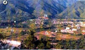
 Sindriyal and his co-workers found as the River Alaknanda enters Srinagar it suddenly flows into an almost six km wide valley. One ponders to think why suddenly a narrow river valley became so broad? Within this valley the geologists were able to notice a fossil river course (ancient course of the river), six levels of river terraces and slip surfaces on the slopes indicated past tectonic activity. The vegetation on the valley slopes is as per the slope, altitude and soil formation. Mean annual rainfall of Srinagar is 1000 to 1500mm and maximum rain falls between June and September when the rivers carry a maximum sediment load.
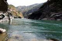
 Seeing the wide valley and features suggesting movements of the floor and the valley sides in the geologic past the geologists studied the slopes first. They found that the higher slopes at altitudes above 1500 m were steep and precipitous, whereas slopes of the lower reaches are undulating types, covered by ancient landslide debris. As soon as the river passes through the gorge at Koteshwar it splits like braids of a teenage girl, swaying gently like the gait of a matured woman. Yet another perplexing feature is the sudden change of the course of the south flowing river through the gorge to west in the wider part. It is most likely that the valley witnessed earthquakes in the geologic past around 70000 years ago.
While making observations they did suspect presence of an ancient lake, now obscured in the area. The problem was how to confirm the hunch? It is a common observation that while the rivers carry sand and generally it is the sand that forms the bottom of the river too. Likewise a lake usually has clay or silt at the base. Therefore in order to confirm they selected four sections along which they collected samples of sediments. These were then subjected to detailed analyses like geochemical and Optically Stimulated Luminescence Studies in the Laboratory.
The evidences that came forth indicated that the streams on both sides of the valley were blocked by landslides in the geologic past. These streams are quite ancient is evident from the fact that they have cut across the ancient river terraces and also the host rocks at places and meet the River Alaknanda obliquely or at right angles.
The researchers could observe distinct 'knick points' along these 'seasonal streams and the lake deposits were found even above them. Sudden, sharp change of gradients of stream like water falls, are termed knick points. Such changes happen when the basement on which a river is flowing is suddenly uplifted due to earth movements. This area is tectonically sensitive and prone to seismic activities, thus such uplifts can not be ruled out. Such sudden movements are also responsible for disturbing the 'angle of repose' of the rocks on the valley slope and causing them to slide.
The relict sediments of the lakes that were formed due to damning of the river indicate that the event (damning) much after the river had started to flow through the area. The lake sediments are found above the second and third oldest terraces of the river. The nature of sediments is such that initially coarser debris material is found then fine sand and then fine clay with marks left by movement of lake dwelling soft bodied organisms.
Debris material indicates a landslide that blocked the stream. Clays with marks of organisms indicate placid, deeper waters of a lake. These clays are often punctuated by debris flow. Which indicates that even after the first major landslide which formed the lake, there were many more over the years.
Most significant finding of these geologists is that there were three lakes in Srinagar valley from 14000 years to 5000 years ago. There was one lake at Badiyargarh around 14ka and remained there till 12.7ka. Nearly two thousand years! Another at Lashmoli was formed around 9000 years ago and remained there for four thousand years. Evidences of a third lake around 5000 years old were found at Dhobhighat. Thus between 14k and 5k there must have been number of landslides that dammed the river and lakes were formed. These lakes must have burst after the natural dam was unable to withstand the pressure from behind!
Historical records of such damn and consequences thereof have been described in this column in the past (Beware the Landlsides!-boloji.com dated 29 October, 2006) and also recent damming of Pareechu river, a tributary of Sutluj in Tibet (A country deluged-boloji.com 3 December, 2006). Damming of the rivers due to landslides and later bursting of such dams has been going on since the Himalayas came in to being. Tracing and dating such lakes formed due to blockade of the rivers in the geological past has been possible only recently and that too due to development of OSL technique. The significance of this study is to map the old, vanished lakes and also study the present slope for their content and stability to forestall landslides that could dam the present rivers.
Himalayas are unstable young mountains and development activities in such terrains need a lot of geological input. It is feasible to make a part of the mountain stable along the axis of a dam pr even part of the reservoir, but it is impossible to make the entire mountain slopes stable. It is however, useful to study the slopes and identify hazard prone areas and take precautionary measures. Thus studying the evidences of relicts of past lakes is a vital step in that endeavor.
16-Sep-2007
More by : V. K. Joshi (Bijji)