
Apr 19, 2024
Apr 19, 2024
'Indians have pretty much gotten used to it: every few years a cyclone destroys a large costal area and claims thousands of victims. The sea penetrates the land up to several kilometers and torrential rains cause little streams to swell into huge rivers that wipe whole villages off the map', says Dr. Guss Stelling a Professor of numerical fluid mechanics at Delft University of Technology, Netherlands in one of his papers. He along with researchers from the 'Waterloopkundig Laboratorium' (WL) and the UK Meteorological Office have been studying A.P. coasts to develop an information system that gives a precise view as to which areas might flood when a cyclone is heading for the coast! A cyclone is nature's fury. It comes as a whirlwind and passes off. But the devastation by the storm surges and floods that often accompany a cyclone has a long term impact. The A.P. coast is known as the rice bowl of the country. The location of the coast is such that nearly one third of the cyclones originating in the Bay of Bengal cross A.P. Cyclones in these areas occur in the pre-monsoon (April-May) and post-monsoon (November-December) periods. The cyclones of the latter period are more severe.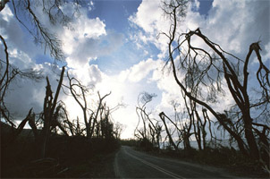 Andhra Pradesh (A.P.) is the fifth largest state in India with 1030 km long coastline bordering the Bay of Bengal from Srikakulam in the north to Nellore in the south. Srikakulam, Vizianagram, Vishakhapatnam, East Godavari , West Godavari, Machilipatnam, Guntur , Ongole and Nellore are the nine coastal districts that face the brunt of the cyclones each year.
Known as Tropical Cyclones in India , Hurricanes and Cyclones in the west and Willie-willies in Australia are some of the names of one natural hazard that brings peril and destruction in the coastal regions, globally every year. Understanding their mechanism, predicting their movement with mathematical modeling, working out the areas most likely to be flooded and after cyclone identifying areas to be most affected by water and vector-borne diseases are some of the issues that are a challenge for the weathermen, earth scientists and health engineers alike.
Natural hazards like cyclones are accepted by the locals in the coastal region as fate accompli. Well no doubt the cyclones are inevitable but the loss of life can certainly be avoided if an early warning system is available and also the people agree to move to safe areas within the given time frame. Dr. Stelling claims he is trying to keep the feet of the coastal populace dry, but yes they have got to move away in time. He says the coast of A.P. is not an American coast where everyone is prepared to leave in their cars in a jiffy.
The India meteorology Department claims that they have strategically placed weather stations that give information about the strength of cyclones and the estimated time a cyclone hit the coast. True. But this system does not give any information on the areas likely to be submerged by the storm surge and floods in the rivers. The river hydraulics at the coast is something completely different than what it is in the mountains or in the plains. At the coast due to low gradient a river carrying its load of sediments becomes sluggish. A concentrated rainfall accompanying the cyclone and succeeding it inundates large tracts suddenly. Again the slopes being meager the spilled over water takes ages to flow out. Large pools of water formed in the area become an open invitation to vector borne diseases like malaria and also polluted waters lead to water borne diseases like typhoid and hepatitis.
The super cyclone of Orissa in October 1999 also flooded large tracts of land on the coasts of A.P. Indian population in general is complacent and dis-enchanted with natural calamities. For the ignorant rural folk a cyclone is a curse which they have to face. For them it is a fate accompli. Many times these people expect someone (the government) to shift them to safer areas and also compensate them for the loss. Thus developing an early warning system therefore needs extra care and effort. For example an equal emphasis has to be given on how much and which areas are likely to be affected by the cyclone, storm surge and floods.
The scientists are also scared about the consequences of global warming, which may lead to rise in the Sea Surface Temperature (SST). The Bay of Bengal which is home to all the north Indian cyclones every year has shown a rise in the trend of SST between 1951 and 1999. However, researchers have claimed that, while there has been a rising trend in all-India mean surface air temperatures, the number of monsoon depressions and tropical monsoons forming over Bay of Bengal and Arabian Sea show a declining trend since 1970. Mathematical modeling has predicted a reduction in the number of tropical cyclones globally. However, the coastal society is in a grip of fear from the nature's fury. Why?
There is no cause for panic though but reasons are strong enough to set up real time early warning systems including flood forecasting. Main reason is country's fast pace of development and faster rate of population growth. In 1999 it was estimated that more than 25% of the country's population lives on the coasts. Naturally the percentage must have risen by now! Lots of money has been pumped on the infrastructure along the coasts. The coastal areas of A.P. are no exception. For example, Vishakhapatnam popularly and fondly called as Vizag is an industrial hub and one of the largest Ports Thickly populated sea-port is always under threat from cyclones. All such areas need special engineering considerations and solutions, because as already said in one of the articles a cyclone generates pressure on structures from bottom to top. Light weight tin roofs are torn like paper. Similarly agriculturally better off East and West Godavari districts face the floods as a consequence of cyclone. Better flood protection facilities and educating the masses about the ways to escape the wrath of cyclones is very much needed. Irony of these districts is that amongst the able rural folk a large majority go to Dubai for livelihood and those who can not, move to Hyderabad to elk out a living. The womenfolk, children and the older men dependent on the earnings of their non resident scions are least willing to move to safer areas in the eventuality of a hazard.
Compared to a tsunami a cyclone moves at a slow speed, about 15 to 25 km per hour. They can be seen forming with the help of satellites and can even be observed moving. Only trouble is their unpredictability. They suddenly change course like a leaf in the storm. Thus predicting the route of a cyclone is a major problem faced by the weathermen.
Since it is possible to identify and delineate cyclone prone areas, it is possible to have mathematical models that give a fairly good idea of the flooding that can take place in a given area after the cyclone. With the help of such models one can also identify areas that can fall in grip of infectious diseases like cholera. Dr Stelling and his team for example, applied a model based on similar studies in Holland. The results were astounding. It was found that water level in deltas can rise about seven metres due to storm flooding at sea and also from the rivers. Thus East and West Godavari districts are very dangerous areas to live in says Dr Stelling. And his conjecture is absolutely right. The river in these districts overflows quickly and inundates vast expanses of rice fields and villages.
The problems of such areas are multifold and to educate and motivate the masses no government can singularly achieve the target. The society and the media have to come forward to rub shoulders with the government to lessen the misery after a cyclone.
05-May-2007
More by : V. K. Joshi (Bijji)