
Apr 20, 2024
Apr 20, 2024
Tsunami of December 2004 was one of the deadliest in the history. Since the time gap between such mega-disasters is huge, there is hardly any available record to act as a reminder for a possible recurrence. Geologists take help of the signatures left by the past tsunamis on the sands of time. Northeast Japan, western North America and Scotland have tsunami deposits that work as long term warnings of possible hazardous tsunamis. They save people from unexpected catastrophes. People affected by the Indian Ocean Tsunami of 26th December, 2004 were not prepared for such an event mainly because there was no historical record of any past, gory incident. "If geological records of tsunamis in the Indian Ocean region had been studied before the event, the regional tsunami hazard may have been recognized and the impact may have been reduced through the implementation of education programs and early warning systems", says Amy Prendergast, Research Geoscientist, Natural Hazards Impact Project, Geoscience, Australia in one of her papers published in Australian Geo News 83, (17-21), September 2006. Yes indeed she is very right, like the earthquakes, the tsunamis too leave legible signatures on the surfaces attacked by their wrath.
Like the earthquakes, the historical and instrumental records for the tsunamis around the globe are insufficient to understand the mechanism and forewarn the people residing in the coastal areas. Study of paleo-tsunamis and tsunami deposits is catching up fast. Of course the tsunami of the Indian Ocean has shaken the scientific community of the region from the slumber and studies have been undertaken on war footing.
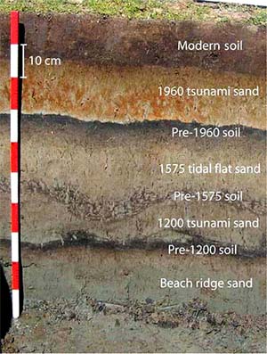 Amy in her paper has wonderfully dealt the ways to understand the paleo-tsunami deposits that give insight about the frequency, magnitude and flow dynamics of the past tsunamis. In other words such studies extend the record of tsunamis by thousands of years. It requires a keen observation to distinguish between a tsunami deposit and a normal sedimentary deposit at the sea shore. One characteristic of the sediments brought by a tsunami is that their layers are always thicker towards the sea and thinner towards the land. This is mainly because the sediments are suddenly 'scooped out' by the waves from the continental shelf and deposited on the coast. The waves lose energy as they travel farther in to the coast thus the heaviest load is dumped nearest to the coast. Often the tsunami sands have an admixture of sand and boulders. The river borne sediments, by the time they reach the sea are turned to sand or clays, while the boulders carried by the rivers are dumped at the foot hills. Such features are indicative of various energy regimes. In the mountains the river has a higher energy because of slopes. On reaching the plains it looses the power to transport heavy loads of boulders. Same way the tsunami waves become weaker on reaching the land and gradually dump whatever they are carrying.
The sediments carried by the tsunami waves have an admixture of offshore and onshore material. Thus mainly the layers are composed of fine to medium sands. The layers of tsunami sediments may vary in thickness from a few centimeters to several meters, depending upon the nature of the continental shelf, coast, distance from the source of tsunami and energy contained by the tsunami. Geologists are able to decipher various layers amongst tsunami sediments and build a picture of different waves that must have attacked the shore in the geological past.
Tsunami waves also scoop out the microscopic animals that live in the sea. In addition there are micro-organisms that thrive on land or in tidal waters. Tsunami waves scoop them out too. It becomes easy for the geologists to identify the environment from where the sediments and the fauna contained therein has been removed by the tsunami and deposited on the beach under attack. Sometimes geochemical signatures of stable isotopes of carbon and oxygen are found from the matter deposited by the tsunamis and useful information about the fresh or saltwater origin of such material is established.
Amy says that when a beach has been visited by several tsunamis over a period of years, it is sometimes possible to work out a succession of layers of tsunami sands. At times it is possible to date the sediments or the organic matter contained therein and the time when the beach was vandalized by a tsunami can be worked out. Similarly the tsunami deposits if spread over a large area can be mapped. For example as per the coastal zone regulations a habitation is prohibited within 500 m distance from the shore. But in case a tsunami deposit is discovered beyond 500 meters then the authorities might have to reconsider implementing local regulations, because the past can always be repeated.
Geologists face problem in identifying tsunami deposits when a coast is also severely affected by storm events. Criteria like a greater extent of tsunami deposits and deposition of tsunami sediments on scoured surfaces are often used. Now a days help of stable isotope analyses of offshore sediments is also carried out to identify how much quantity of such sediments is present in the suspected tsunami deposit. However, the distinction between a tsunami deposit and a major storm deposit is often disputed and the experts do recommend further studies to understand the differences.
Australia faces the threat of possible tsunamis. Amy has worked out the possible threats of tsunamis from the north and east. Undersea activities that result into a vertical displacement of the sea surface can generate a tsunami. Undersea subduction zone earthquakes are the most common mechanism for a tsunami. Earthquakes around Australian margin can create tsunamis that can reach the shores within hours. The Australian Plate is subducting underneath the Sunda Plate of Indonesia. This feature is a source of constant tsunami threat to the northwestern coast of Australia.
The eastern coastline of Australia is densely populated and it has several tectonic features in the offshore region which are a real threat for the region, because they can generate tsunamis. In the past too the tsunamis that have struck the region were due to these tectonic reasons.
A lot can be deduced from tsunami geology about the past tsunamis which is useful for planning tsunami safe development along the coast. Such studies are already being done in several countries. The science needs to be pursued vigorously along Indian coasts as well. We have a far dense population settled along the coast and in order to save life and property it is imperative that research on past tsunamis is carried out actively.
The coastal areas have lots of problems. We will read about some problems the Andhra Pradesh coast faces in the next issue.
03-Mar-2007
More by : V. K. Joshi (Bijji)