
Apr 23, 2024
Apr 23, 2024
 Floods have been there ever since the drainage system of the earth's surface came in to being. There are myths almost in all religions about the great floods. As per the Wikipedia the stories of Noah and the ark in Genesis, Matsya in the Hindu Puranas, Deucalion in Greek mythology and Utnapishtim in the Epic of Gilgamesh are among the most familiar versions of these myths. A large percentage of the world's cultures past and present have stories of a "great flood" that devastated earlier civilization.
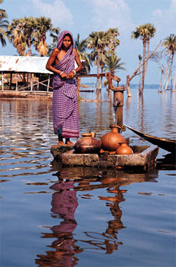
In other words floods have been ravaging the human societies since times immemorial. In India nearly eight million hectares of land (about 2.73%) pf geographic area are annually flooded says K.S. Valdiya a renowned Earth Scientist and a great teacher of Geology. Nearly 32 million Indians experience the deluge year after year. The number of people affected keeps swelling each year. A report of the Central Water Commission (CWC) says nearly 37 million hectares (m ha) of fertile land are prone to floods annually. Lush green fertile fields forming a prized land constituting 3.8 m ha are ravaged by the floods making nearly 32 million people depend for their food on doles from the government, NGOs or forced to search alternative source of living.
Rivers have been considered sacred by our ancestors. Even today the rituals of bathing in rivers on particular occasions are religiously followed. It is a different issue that the rivers have been converted to refuge carriers.
The rivers in India have different dynamics in different parts of the country. Rivers in the Himalayas for example, are most dynamic and frequently affected by earthquakes and landslides. Co-seismic landslides are frequent and the lose rock mass and mud slide down the slope to get dumped in a rivulet/river. Sudden onslaught of material obstructs the stream, creates a lake behind. When the pressure of water from behind exceeds the limit of tolerance of such a blockade, it gives way and leads to flash floods in the downstream. Climatic factors also cause landslides. The rain soaked mountain slope decides to slides down. Whether a blockade is created or not the total load of the stream down below is increased many times. This changes the hydraulic gradient of the river and upsets the natural balance of the channel.
Flash floods have been taking place in the Himalayan terrain since ages. However, they have become exceptionally frightening because of the settlements along the rivers and heavy investment by the government to generate hydroelectric power.
Recently in mid 2005 Pareechu River a tributary of Sutlej in Tibet was in the limelight. Flash floods due to possible bursting of a natural dam formed across Pareechu River were expected. As per the newspaper reports as a precaution more than 3000 persons were evacuated and taken to safer places to escape the fury of Sutlej in the higher reaches of Himachal Pradesh. Nathpa-Jhakri Project (NJPC) that generates 1500 Megawatts (MW) power from the mighty Sutlej had to be shut down. Satellite imageries of Pareechu River were studied by the Survey Of India (SOI). The study indicated a 60 metres deep lake formed on the course off the Pareechu River. The lake was spread over an area of 230 metres. It was estimated that the lake contained 114 million cubic metres of water.
What if the lake bursts was the major cause of anxiety. RMSI, a global company for Geographical Information System (GIS) solutions had independently worked out that in case of a lake burst approximately five lakh persons would be affected. Based on 2001 census and remote sensing data they postulated that Rampur (230 km downstream from the lake) in H.P. may be submerged under five meters of water. The situation was indeed alarming. A similar flood in 2000 took away 70 lives, damaged around 100 bridges and also damaged the power plant at NJPC.
Sutlej is a mighty river that originates in Tibet at an elevation of 4500 meters from Lake Mansarover and Rakas Tal. Prior to entering Indian Territory near Shipki La in Kinnaur district in Himachal Pradesh it travels some 320 km in Tibet. The catchments of Sutlej upstream of Rampur are 51000 km2 of which 37000-km2 lies in Tibet and 14000 km2 in India.
The hydropower of Sutlej River basin is estimated to be 9000 (MW), out of which 1500 MW has only been tapped so far. Projects for tapping another 1500 MW are being developed.
A river basin with such a high potential for power generation is certainly an asset for the nation. However, the altitude, terrain conditions and geomorphology of the area warrant specialized feasibility studies for full utilization of the asset. The investigations carried out by the Geological Survey of India (GSI) enumerate that the area falls in the zone V of the Seismic Zoning Map of India. Kaurik fault an active fault passes through the area. The Kinnaur earthquake of January 1975 and 1997 are attributed to this fault. An earthquake of intensity M+8 rocked neighboring Kangra in 1905.
Huge debris fans at the mouths of most of the tributaries of the Sutlej indicate freak and sudden erosion episodes, a consequence of past cloudbursts. Accumulation of snow in the higher reaches of the mountains and excessive rain during monsoon adds to the total water content of the jointed and sheared slope forming material. Water acts as a lubricant and the rock mass slides down as soon as the angle of rest is disturbed. Upper Sutlej valley has such gravitational landslides and landslides generated by the earthquakes as well. Scars of landslides generated by Kinnaur earthquake of 1905 are still visible. Geologists have observed that the upper reaches of Sutlej River were prone to cloudburst in the pre-historic days as well. Apart from the risk to lives and property, the cloudbursts cause great damage to the engineered structures. The load of silt carried by a river during a flash flood is doubled than during the tranquil periods. Therefore the problem is compounded.
Harnessing the river is essential for developing hydropower for the Country. While the engineers have to keep in mind the advice of the geologists about the high seismicity and possibilities of flash floods, the residents need to be constantly enlightened about the natural hazards that haunt the area. Habitation should never be permitted below the highest flood level.
Despite the flash floods of 1997 and 2000 we were caught napping in Sutlej valley in 2005. Suppose there was no warning from the other side the consequences could have been beyond imagination. In the age of Information Technology and Remote Sensing it is not difficult to foresee such mishaps. Provided we have the will to 'see' them!
Not only Sutlej , there are many major rivers that transcend from across the international borders. Brahmaputra is one such classic river. The floods of Brahmaputra and its tributaries are a big annual hazard.
We will read about some more floods in the Indo-Gangetic Plains in the coming issues.
03-Dec-2006
More by : V. K. Joshi (Bijji)