
Apr 24, 2024
Apr 24, 2024
Nainital, a jewel of Uttaranchal was once upon a time known as 'chakata' in local language. Meaning the city of 60 lakes. Most of the lakes have disappeared today except a few including the Naini lake. Nainital is still called a lake district because apart from Naini lake few others like Bhimtal, Naukhichiya Tal, Sat Tal etc though shrinking fast, have managed to survive till now.
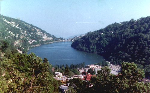
According to local belief the origin of Nainital dates back to mythological times. Sati, Lord Shiva's consort committed suicide at the yajna of Daksha Prajapati. When Lord Shiva roamed across the universe carrying her dead body, Sati's eye fell near the lake, where the Naina Devi temple now stands. The waters of the lake are therefore considered sacred and the Naina Devi temple is the venue of an autumnal fair. In ancient times, the lake was also known as the Tri-rishi Sarovar, the lake of three Rishis, Atri, Pulastya and Pulaha.
For Mr. P. Baron, a merchant and hunter from Roza near Shahjehanpur in U.P. it was love at first sight, when he visited Nainital in 1841. He immediately constructed a house there, aptly named as 'Pilgrim's Cottage' and wrote, 'It is by far the best site I have witnessed in the course of a 1,500 miles trek in the Himalayas'. His was the first of many residences, which were to transform Nainital into a popular resort. By 1858, Nainital became a well-known hill station, and within a few years became the summer seat of the provincial government.
Large tracts of Nainital town are located on stabilized ancient landslide debris. Nainital has a history of landslides. Several of these are recorded in the annals of Geological Survey of India (GSI). Surrounded by high ridges on all sides, Nainital is like a bowl with water at the base. Sher-ka-danda ridge runs Northwest-Southeast of the lake. In 1867 a landslide swept away part of a cottage and endangered the famous Nainital Club. Again in 1880 a heavy rain mobilized the Sher-ka-danda ridge and the landslide took toll of 193 people. The magnitude of the slide was such that a huge part of the lake was filled up. Consequently the 'Flat' was created. A British visitor had taken a picture of Sher-Ka-Danda ridge a day before the slide. He was a witness to the slide and was lucky enough to survive and grab a picture after the slide. He described that within eight seconds the lake was filled up with debris. Imagine the magnitude of mass wasting! The two pictures are the pride of the Municipal Library at Nainital.
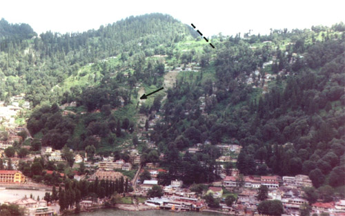
Arrows indicating trace of old landslide
The human memory is volatile. We seem to overlook or forget the immediate past what to think of the history.
The slopes of Sher-ka-danda with myriads of houses appear as if everything is quiet and the mountain is stable. It is perhaps a lull before the storm! The pillars on the slopes have shown a movement of approximately two centimeters per annum. The Grand Hotel at the toe of the slope has shown a subsidence of more than 1.5 meters in past the three decades. Even the trees in the mid-lake portion on the northern flank are tilted 10-350 due South (i.e. towards the lake). Common sense says that trees are supposed to grow vertical. A tilt indicates that the ground is slowly creeping down.
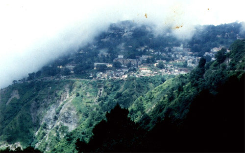
A Habitation Endangered!
It is almost unimaginable to realize that the slopes on which the Secretariat (Now the High Court) and other buildings are constructed are made up of accumulated debris. This came from the landslides that originated on the steep upper slopes of Naina Peak. The British were meticulous and constructed a network of storm water drains on these slopes. These drains culminated at the lake. The drains used to be kept scrupulously clean and water passed through strainers before reaching the lake. As a ten year old kid, with a streak of an explorer I remember 'exploring' the tunnels these drains passed through on dry days. Nainital is situated on Limestone. Lime dissolves slowly in water and allows water to percolate in. Water acts as a lubricant. That is what caused a sudden rock-fall from the Naina Peak in September 1987. A study by the Geology Department, Kumaun University shows that the slope at the top of Naina Peak , consequent to this episode has developed a vertical displacement of 170 cms. Most of the houses in the area have developed cracks and once a threshold limit is crossed the slope may get mobilized again.
It is a common feature in the Himalayas that landslides are triggered as a result of saturation of loose soil, debris or even jointed rocks with water. Nainital has quite a high incidence of rainfall. The storm water drains are choked; houses have replaced trees. There is a competition to build more and more houses to earn more money. Alas, if the mountain decides to slide as it has been doing since historical past; all the money earned would be swept off. Loss of life would be stupendous. Uttaranchal Government should reconsider all the hillside safety reports submitted by the GSI since 1880. Improve the drainage system and stop further construction.
V.K. Sharma of GSI, an expert on landslides has carried out detailed studies of Nainital area. Using the data collected on slope forming material, slope morphometry, drainage and kinematic analysis of slopes he has identified four zones with vulnerability to instability ranging from low to high. The low hazard zone occupies parts of southern slopes, i.e. Ayarpatta area. Here he says natural slope conditions can be utilized for urban development. The next zone is moderately prone to landslides and forms part of Ayarpatta and Sher-Ka-Danda ridges. This zone he says can be made use of after providing required slope treatment measures such as network of lined, surface network of drains to tap the run off. Zone III forms parts of Sher-Ka'Danda ridge and the Rajbhawan areas. This zone needs heavy treatment of slopes to save the existing structures from rock avalanches. The zone IV is a high hazard zone and forms flanks of Balia Nala and Sharma says habitation on this zone is suicidal. The cost of treatment is prohibitive and as such it is totally unsuitable for development.
In all probability majority of the 60 lakes of this region got filled up with sediments and later landslides obliterated their signatures! Perhaps same fate awaits Nainital! The developers and planners need to wake up now and take lessons from the past. If those dreaded eight seconds are repeated again the loss of life would be unimaginable. Let history not repeat itself this time.
November 5, 2006
05-Nov-2006
More by : V. K. Joshi (Bijji)
|
|
Thanks Sah ji. Nainital is already choked beyond capacity. The govt and the local body should come with a heavy hand upon anyone constructing even a room. The consequences are going to be severe. It is already rather late to save Nainital. I just pray that the Nature doesn't hit back. |
|
|
Thanks Dr D.P. Pande |
|
|
Wonderful article on general geographical status of Nainital. And to my under- standing there is a limit to weight bearing capacity of any dimension. Perhaps the planners would check that on geographical, environmental, social and development dimensions, how much we can to sustain on those singly and collectively. |
|
|
Excellent article Environmentlist and GSI must take proper guidelines. |