
Apr 20, 2024
Apr 20, 2024
Continued from Grandeur of Grand Canyon
Natives used to Cremate
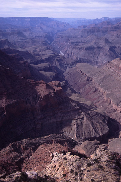 A little farther we reached Yaki Point, jutting into the Grand Canyon. To our left were columns of rocks whose heads appeared like the pyramids or pagoda shaped domes of South Indian temples - the cap becoming narrower and narrower, layer by layer, and each layer rounded to remove the sharp edges enhancing their softness. Therefore calling these stone caps or structures as temples is doubly justified. From here Zoroaster and Brahma temples were closer and due north. With little imagination one could almost see three whitish heads of Brahma (fourth being invisible) over red shoulders. As the river Colorado in this region is flowing from east to west, the Rim Drives are also east west. Therefore north direction is the natural direction to gaze at, thus temples or peaks due north attract our attention first. Probably this is the best point and time to have a look at 6071 feet high O'Neil Butte, (rhymes with 'cute') for it is closer and the morning sun bathes it in the warm red rays. My eye following the crag reached this attractive rock formation. It is a formation that has tallish steep sides of Redwall limestone at its base, which make it look like a freestanding structure. Then there are thin gradual slopes alternating with thin vertical sides, culminating into a peak. The width or breadth of the Butte was not small in proportion to the height. If the width at the top is smaller, it becomes a tower or a column. Wind and water have eroded Coconino, Toroweap and Kaikbob the three top layers of this Butte, thus its top is made of Hermit shale, the fourth layer of surface of this region. It means another 30 million years of sedimentation has been eroded compared to the upper Kaibob layer. On the near right, Cremation Creek could be seen in its glory, starting from a point slightly to our east and flowing north to meet the River, regardless of the name given to it. The name Cremation intrigued us. Natives prior to Christian influence despite shortage of wood used to cremate their dead, and this was one such place. The South Kaibab Trail as viewed from this point was alluring also because we would be returning from Phantom Ranch via this trail the next day.
The Yavapai (a Native tribe) Point (7040') also juts in to the Grand Canyon, leaving the east - west line of the Rim. It offers a breath taking view at a closer range of sweeping vista of vertical cliffs, shrubby steep terraces and deep gorges. I could get a view of the silver line of the Colorado River, deep-set in the black rocks,. Buddha and Manu Temples were seen due north. Buddha with its silver 'kalash' (crest) easily dominates the scene due to its massive and majestic shape. Manu is north of Buddha and is slightly smaller and lower in altitude. I was captivated by other than 'Hindu' peaks also. From this Yavapai Point, I saw the Egyptian Pyramid "Cheops " (5401'), almost due north and halfway to Buddha. Northwest of Cheops and southwest of Buddha is Isis Temple with twin peaks, the Egyptian Goddess of nature, and wife of Osiris the God of the dead. The Egyptian god and Goddess were not separated; Osiris is to west of Isis.
Natural Battleship
We started on the West Rim Drive. It being not the tourist season, we were permitted to drive our cars on the Drive. In crowded days of summer months one either treks or uses public transport. We reached Maricopa Point (7000'). The car park here was far from the observation point, and there was an attractive grove of mountain juniper and pinyon pines. Sandeep decided that it was a good spot for picnic. The people passing by would avoid looking at us, now that we were picnicking; if however our eyes met, then there would be a polite smile on their faces. I have noticed that most of the Americans do so regardless of gender or nationality or colour difference. But I have seldom seen this friendly gesture in an Indian towards an Indian! I wonder why! Is it because the other person may be a Pakistani? Even if he is, so what? We walked to Maricopa Point. Very close in the northeast direction was an intriguing formation, too realistic to be natural - 'a battleship'! When somebody pointed at the Bright Angel Trail, my ears straight away caught the attention and my eyes the Trail, which we were going to descend the next morning. Standing on whitish tan colored Kaibab hard surface, I saw coils on coils of a huge python zigzagging and descending through thick layers of Kaibab, Toroweap, Coconino and Hermit shale, laid 250, 260, 270 and 280 million years ago (mya) respectively. After that there was a gradual slope till the 'Indian Garden'. Kaibab is sandy limestone cream colored, and Toroweap is slightly darker than Kaibab. Creamish and tan Coconino consists of many layers of sandstone rocks. Hermit was easy to distinguish because of its bright red colour - sedimentary layers made of silt. The trail was going along Garden Creek, with a rocky wall on one side and the Creek below on the other! I started imagining my mule ride of the next day- would it be very painful, dangerous? Ah, but it would be exciting and enjoyable.
Grand Canyon and Atom Bombs
An anachronistic structure of iron caught my attention. It was the remnant of a huge mining enterprise that began in the late 19th century but really flourished in mid twentieth century, functioning till 1960s as the USA's richest uranium mine. It began as a mine for copper, silver, lead and asbestos. The iron ruins of the mine do not look pleasant, especially because they contrast harshly with the natural (ruins) landscape. Right in front, there was a bright point for nature conservationists, a fence that prohibits visitors to walk in to an attractive green area. It is the only known place where plants 'sentry milk-vetches' are found. Because of treading by tourists it was being driven to extinction. Now it has been declared as an engendered species and is therefore being protected. This non-toxic milk-vetch was known for increasing the milk output of goats.
Orphan Produces Billions of Dollars
Not very far was the Powell Point, recessed in to the land and therefore with a narrower view. There is a memorial of John Wesley Powell, who has been honored by naming the artificial lake formed when Glen Canyon Dam was built about 170 kms upstream from here. This dam has changed the river, or shall we say 'tamed' the river. Noe it could be called a 'river-canal'. Powell was 'the maker of the Grand Canyon', i.e. the one who transformed it from the most useless place to one of the most wonderful places in the world. Nearby ruins of tower of the Orphan Mine were a perfect example of an eye sore. It was started in the 1890s as a copper mine, but soon the prospectors found out that catering to tourists was more remunerative. Like the mine at Maricoapa Point, it also had glorious days when it struck uranium. It did make its prospectors multi millionaires (those days) by producing more than 2000 tons of uranium, 3000 tons of copper and tons of silver.
Shiva The Highest
The next observation point was 'Hopi Point'. It immediately appealed to me as the most attractive point that we had seen so far. It juts significantly into the Canyon, and at a height of 7065' it is the highest point on the West Rim. It gave a grand panoramic view from east to west. Towards northeast, there stood a thick 'red wall', going southwest to northeast, shining, well, burning bright. It is Red Wall, 330 million years old. It consists of limestone and has been colored red by rainwater bringing down iron oxide from Supai and Hermit layers lying on top of it. In the same direction, one can have a glimpse of the River flowing gently in between dark black Vishnu rocks. Right in front (i.e. north) was the most dominating of the temples, Shiva Temple (7646 feet)! In the round table conference, with Shiva as the head, could be seen, west to east, Confucius Temple (7081), Mencius Temple (7001), Tower of Ra (6076), Osiris Temple (6613), Isis Temple (7006), Buddha Temple (7212) and Manu Temple (7184). At 7646 feet Shiva is the highest temple here. I immediately thought of 7533 feet high Vishnu Temple. Did a Shiva devotee influence Clarence Dutton? Then I recollected a remark by John Annerino (author of 'Hiking the Grand Canyon'); "Vishnu Temple is the largest and the highest detached mountain in the Grand Canyon." Well, interesting! One more fact is interesting. The top layer of 'Vishnu Temple' is Toroweap, and that of Shiva Temple is Kaibab; it means that the Kaibab layer from the Vishnu Temple has been eroded.
Hermit's Restaurant
It was 3:30; we had to decide the Point from where we would watch the sunset. Hopi appeared to be a good choice, but there were some more Points yet to be seen. We decided to leave Hopi Point and hoped to come back for the sunset. Mohave (6995) Point was also attractive, we could appreciate the aura of Osiris better with the wall of the North Rim forming an impressive multi-colored screen behind. We moved further to Pima Point. Right in front we could see a huge amphitheater suitable for at least one hundred thousand persons! The last Point left was Hermits Rest. It is a beautiful place with green pinyon and juniper grove. The restaurant really makes you feel that if you wish to, whether or not a hermit, you ought to take rest here. The architecture of the restaurant was so unassuming and yet so calm and cool that, probably, only a hermit's place could be so peaceful and charming. We rushed back to Hopi Point.
Fascinating Vastness
We had reached well in time for it was 4:15 only and the sunset was at 5:20. A crowd had started gathering at the Hopi. Cameras were being clicked merrily. I settled down on the parapet wall, my camera above the heads of the persons ahead. I started feeling the entire scenario. The vastness, innumerable rock formations, the unearthly earthy colors - reds, browns, cream, tan, greens - rich and vibrant, the slim and the vulnerable River still smiling, all this was not merely tantalizing, but was fascinatingly rapturous. I noticed that Confucius Temple, Mencius Temple, and Tower of Ra (Egyptian Sun God) would be mostly in silhouetted forms, as they were to west of us. Shiva, Osiris, Isis, Buddha and Manu Temples would shine in full warmth of the evening sun.
Sunsets On Ra
'Ra' appeared in no hurry to depart to his abode, there was still time for photography, and I started musing. Suddenly it occurred to me that these temples and towers appear to be higher than we are, but all of them are not. Only Shiva and Vishnu Temples are higher than South Rim and that too by about only100 to 200 feet. This is so because North Rim is higher than South Rim by about 2000 feet, and these Temples are on the north of the River, closer to North Rim. It also means that all the Temples and Towers are lower than the North Rim. Once upon a time, some million years ago, this Colorado region was a vast plateau with some layers on top of Kaibab layer, those layers in the meanwhile got eroded, leaving the Kaibab on top. Then about 6 mya, river Colorado started to flow and very gradually started cutting its path on this plateau. As it went deeper and deeper, it should have left but one very narrow canyon, or narrow canyons formed by its tributaries. How did the Canyon widen to as much as 15 kms?
Formation of Fantastic Forms
There are always cracks on the surface of earth. Rainwater seeping through them would dissolve the soluble portion and take it away making cracks deeper thereby isolating the rock from the main structure by forming crevices. For a crack nearer to the wall of the river, the phenomenon can be more effective. Now a portion of the rock thus isolated becomes vulnerable to forces from both sides. In winters, water would freeze in those crevices and by its expansion during freezing, would tend to break the weaker portion, thereby widening the canyon faster and further or create those dazzling temples, tantalizing towers and majestic mesas. This is a simple explanation of the amazing, captivating and spellbinding magic that was in front of me. But these forces and the layers and similarities can be found at other places, but not the Grand Canyon.
Heavenly Blue Descends
The question came back - why do the Temples and Towers appear to be higher than we are? The departing Ra had created darkness below by creating long shadows, and the Temples and Towers seemed to rise immensely from the dark depths, shining with divine warmth. This gives them a loftiness that is part of our feelings, of awe, of wonder, of fascination, etc. The sun not only gave the Temples a deep reddish hue, it gave them an almost invisible touch of gold which changed the whole atmosphere into a sublime and heavenly one. I saw heavenly blue descending on the temples, and royal purple on buttes; and the sunny golden gradually ascending, giving the atmosphere even more mysterious purple diaphanous veil which was becoming darker and darker and darker. This would be a grand place to be on a full moon night to soak oneself even more with the mystery of this place. If I have conveyed even one tenth of the joy I felt, I would feel very happy.
I am reminded of Tulsidaas, the great medieval poet of Hindi, the author of Ramcharitmanas, who said that the eyes see, but cannot speak; and tongue that speaks cannot see and therefore cannot do justice to the actual experience of beauty and joy.
Previous Page
Image (c) William C. Gladish
21-Oct-2001
More by : Vishwa Mohan Tiwari, AVM (Retd)