
Apr 18, 2024
Apr 18, 2024
Continued from India-centric Hydraulic Civilization of the Old World
 Like Qanat, the origin of Surangam is also unknown. Even though the irrigational and domestic needs of Kasaragod are met for centuries, no one in Kasaragod is able to say about the origin of Surangam. In the absence of any written documents they may appear to some as if they are natural or Devakhaatam. Others stretch their mind’s eye to the historic times to the Middle East. They say that the trade contacts with the Middle East facilitated the technology transfer to Kerala by the Arabic Muslim experts who had come to India and settled down in the Malabar coast at the end of the 7th century. Since history speaks about Quanat as a concept strongly rooted in several Middle Eastern countries like Iran and Iraq from 700 B. C onwards, Arab traders might have introduced the concept to Indian shores. Kasaragod was under the Madras Presidency during the British rule. The British records speak about agriculture as the chief industry whose cultivation depended mainly upon rains. Later, crops were raised partly by supplies of water drawn from streams, natural pools, private tanks and wells. The British seem to have noticed no traces of any Surangam. The question whether the technology is indigenous or imported remains to be answered.
In Kasaragod, there are 510 Surangams and by another estimate 338 surangams have been located. We find a large number of turankam in Kasaragod where it is known as surangam and turappu in some other part of the district. Each and every homestead in Kasaragod, has only a type of flowing well surangam.
A tunnel is turankam in Malayalam and surangam in Sanskrit. A conduit, underground passage is turappu. A large well, for irrigation purpose as well as a mine is turavu. A structure resembling a tunnel, as well as tunneling, is turavu. A shaft made for mining a mine is turankam. Soil dug out in a heap by rats is turu. To bore/ to make holes is turavuka. turakkuka. One who is engaged to drill is turavan. A drill for boring holes is tamaru, tamaruli, turappanam. One can find in Kasaragod several surangam and the vertical wells are not found at all. Surangam is a loan word from Dravidian turankam.
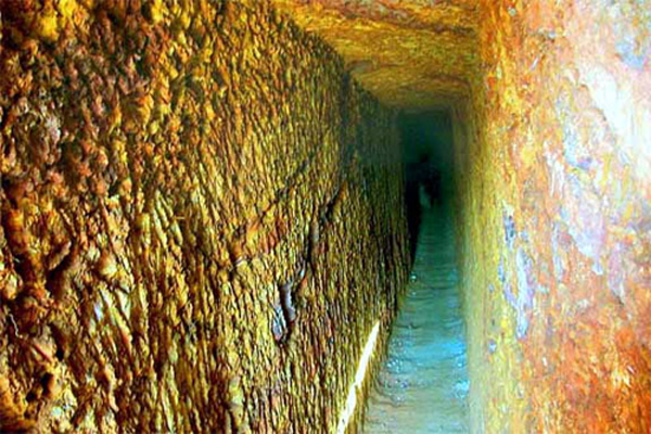
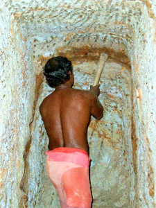
Unlike the Qanat, the surangam is a horizontal flowing well. Qanat is a vertical well with tunnel at its bottom designed on the basis of simple law of gravity. While the distance of Qanat is counted in miles, the surangams are 3 to 300 mts only. Where the access shafts are made for digging of the tunnel the vertical shafts are made for facilitating air circulation inside the surangam. While Qanat diggers are a class by themselves surangam is only a handicraft of some thrifty intelligent farmers to find water for their family as well as their field. Qanats are excavated in desert environment unlike surangam. An experienced digger of wells can easily dig a horizantal well. In Indian forests the tribals are seen extracting water from the aquifiers with the help of short bamboos. Hollow bamboo is inserted on the tube- like structure made out by piercing a strong stick. Only these fundamental principles are applied in Surangam.
Koopasastram
The science of divination for the construction of wells, tanks etc is Koopasastram. Vasudevans Koopasastram is a well known treatise. In Sanskrit udakam is water. Argalam means a bar, obstacle, check or impediment. Varahamihira defined udaka(ar)ggalam as an obstruction or impediment to water. As such, it is a method to divine the presence of water. Dakshamta is dexerity. It needs dexerity to remove the rocks, which obstruct the water by drilling a hole horizontally with the basic equipment like pickaxe and wedges. The art of drilling Suranga is a handicraft. The villagers in some coastal areas of Kasaragod and the southern Karnataka practiced it for generation and made it almost a tradition.
Most farmers of the villages like Bayar, Manila in Karnataka know the art of drilling Suranga and find the supplies from their Suranga adequate. The native girls of Karhad Brahmin community go to Goa after marriage. Goa is said to have known about Suranga technology from these girls. The belief that this community in Karnataka is a migrant one from Karhad, points Maharashtra as the place of origin of Surangas. It should be noted that a set of people known as kutayaariyar are probably considered as the Aryan race in Coorg.
A glance of the mountain will suffice to induce the diggers to fix where exactly to drill the hillock to reach the storage of pure drinking water. This has made the diviners touch almost a magic. Their observation to fix the water table includes the study of factors like the hills slope and geo-system. Apart from that the presence of termite hills and some trees like Pala (Alsteria Scholaris) too indicated water availability. The presence of rubber trees these days is an indication of limitation of water. Their precise knowledge on the water flows, directs them to dig the tunnel with a slight rise. Palaghat in Neeleswaram Panchayat Palayi, Palayavayal in east Eleri are the place names connected with Pala tree.
Qasr
We began our discussion by examining the Qanat attached to the qasr of Nalut. Qasr is a castle or palace. Its q is unvocalised. Located 80 km east of Palmyra and 80 km south of Dayr al-Zor on the Euphrates. The Qasr al-Hayr East represents a large complex, which may be divided into four main groups: the small enclosure, the large enclosure, the bathhouse and the outer enclosure. The small enclosure is a square building, approximately 70 m per side, with two solid semi-circular buttress towers on each side and four round towers at the corners. Two half-round towers on the western side through a monumental gateway flank the entrance. The lintel of the gateway is made of joggled voussoirs above which there is a relieving arch outlined by a continuous moulding which also runs along the front of the towers. On either side of the relieving arch there are shallow recessed niches with engaged side columns. At the top of the gateway is a panelled frieze, in the centre of which there is a projecting machicolation. Inside there is a courtyard with a central pool around which there is a columned arcade or portico. On the north, east and south sides the rooms are arranged in groups of three with a central room and two rooms on either side. At the north- and south-east corners there are small rooms with latrines set into the wall. On the west side there are two long vaulted rooms on either side of the gateway, which includes a mihrab in its south wall. The pattern of the upper floor is similar to the ground floor. The building probably functioned as a khan. The large enclosure has a similar plan to the small enclosure but is much larger, measuring 167 m per side. This building also differs in having four axial entrances leading into a large central courtyard lined with an arcade. The internal plan comprises twelve structural units, eight of which (two per side) are courtyard buildings. Three of the four corner units seem to have been open areas, whilst the southeast corner contains a small mosque with a raised central aisle. One of the courtyard buildings on the east side appears to have been an industrial building for the production of olive oil (i.e. presses and vats). The function of the building is not clear although it may have been a governors residence.
The bathhouse comprises a triple-aisled hall with cold plunge pools, a series of three hot rooms and a warm room with a heated pool. The complex included a furnace, latrines and two service rooms. There were two separate sets of latrines and two entrances, which imply that there may have been some sexual segregation.
The outer enclosure from which the complex derives its name (Hayr) is a vast wall of irregular shape, which stretches for more than 15 km. The wide wall is buttressed internally and externally with solid semi-circular buttresses. Four gates were discovered, each contained within pairs of circular buttress towers. The purpose of the enclosure is debated, although it may have been partially for water conservation, for agriculture and animals (domestic or wild?).
Castle
Kasaragod is said to have been the seat of a big palace in the past. Although there is no evidence of a palace, Bekal Rama Nayak, a local Kannada writer has traced the etymology of the word Bekal to Baliakulam meaning big palace. The term Baliakulam came to be known as Bekulam and later as Bekal. From inside the fort a secret tunnel leading right into the sea can also be found here.
The popular meaning of qasr, an Arabic word, is a royal palace, garrison or mansion. But qasr might have originated from the Sanskrit word kasaaram. This word can be found in usage in India, Africa and the Middle East.
Alczar
Many of the cities of Spain have an alczar, which means Spanish castle. They are fortified structures built in the 14th and 15th centuries. The term is derived from the Arabic word al-qasr, which means castle/ fortress. It is a group of buildings surrounded by walls. Generally rectangular in form, alczar have easily defensible walls and massive corner towers. Inside the alczar was a large open space (patio) surrounded by chapels, salons, hospitals, and sometimes gardens. This is considered both as a fortress and as a palace. A chain of fortresses was built during Ptolemaic and Roman times. The settlement known in ancient times as Takhoneourit is one of them. To the Greeks, it was Tchonemyris, meaning The Great Well. Being a major water source in antiquity the town would have been a stop- over to many a traveller overnight. The remnants of the well can still be seen adjacent to the mudbrick enclosure wall on the western side. The availability of water in this part of the oasis enabled the town to grow large and added to its prosperity. It is here that the cemeteries of the ancient community are to be found. A major desert route which led from Qasr el-Zayyan to Esna during Roman times, testifies to the importance of the settlement which consitutes the lowest part of the Kharga depression, at 18m below sea-level.
Kasai River in the southwestern Africa is a famous example. The river rises in central Angola and flows east and then north and continuing northwest through Congo, empties into the Congo River on the border between Congo and the Republic of the Congo. But in the Middle East Kasaram is spelt as qasr. There are several place names with qasr as pre/suffix such as Qasr Libya, Umm Qasr (Iraq); Al Qasr (Egypt), Qasr Azraq, Qasr Hraneh (Jordan); Qasr Naous (Lebanon); Qasr Ibn Wardan (Syria). In India we have several such place names. Apart from Kasaragod in Kerala we find that the place name occurs in other parts of India: Kasar, Kasara, Kasaram, Kasara Pier, Kasarda, Kasare, Kasareddipalli, Kasarhalli, Kasari, Kasari River, Kasarjaola, Kasarkod, Kasar Sirsi, Kas Balari, Kasalran- Jammu and Kashmir; Kasan (Haryana); Kasandra (Gujarat); Kasangi- Madhya Pradesh; Kasar (Rajasthan); Kas, Kasa Khurd, Kasal, Kasar Sirsi, Kasara, Kasarda, Kasare, Kasarhalli (Maharashtra); Kasal, Kasaram, Kasareddipalli (Andhra Pradesh). On Indias east and west the following place name occurs: Kasar occurs in Bangladesh, Bosnia Hercegovina, Croatia, Indonesia, Kenya, Pakistan, Philippines, Turkey. Ras Kasar (Eritrea); Shatt al Kasar (Iraq); Sungai Kasar (Malaysia -2); Wadi al Kasar-udan; Wadi al Kasar (Yemen); Kasara (Chad-2); Kasara (Namibia); Kasari, Kasari Saar, Kasaritsa, Kasara, Kasariy, (Estona); Kasara (Bulgaria); Kasara , Kasarikhola (Bangladesh); Hadjer Kasara (Chad); Gora Kasara, Kasaradon (Georgia); Foho Kasarae (East Timor); Kasarafam (Cameroon); Kasarami, River Kasara, River Kasaragu (Nigeria); Kasarai (Papua New Guinea); Kasaraj Ljusnes, Maji i Kasarajt (Albania); Kasaral El Barke (Mali); Kasarama Creek (Guyana); Kasanamba Hill (Malawi); Kasaranga (Solomon Islands); Kasarangan (Indonesia); Kasa-ri, Republic Of Korea (5); Kasari- Mauritania; Kasari (Uganda); Kasari (Burkina Faso); Kasari, (Democratic Republic Of Congo); Kasar Koh, Kasari Laghab, Kasari, Pakistan (3); Kasaria (Tunisia); Kasalia (Kasaria Stream) (Zambia); Kasarichi (Belarus); Kasari-wan, Kasari-saki, Kasari, Kasari-machi, Kasari-saki, Kasari-mura (Japan); Jazirat al Kasarinah (Egypt); Kasaringa, Kasarini Estate, (Kenya); Kasarinvaara, Kasari Seamount- Underwater Feature; Kasariselka (Finland); Kasa River- Philippines; Kasarka, (Russian Federation); Kasarcilar, Kasarkoyu (Turkey); Kasara, Kasar Lakbir (Morocco); Kasarlija (Bosnia Hercegovina).
In Kerala the place name, Kasaragod, bears the seal of kasaaram. Kanjiram and kasaaram rhyme. This might have caused trouble to define the word Kasargod. Qasr is a palace, fortress or mansion. Qasr Al-Abd means a palace in the lake. Kasaaram means a land of lakes.
In the article Biography of the place named Kasaragod, the word kasaram has been explained to indicate wetlands. The paper on Qanat begins with Nalut and qasr. This word rhymes with kasaram. Both are wetlands. More over wetlands known as qasr can be found through out Middle East. Castle is from qasr. And qasr might be from kasaaram. It indicates that the early settlements were in the wetlands like the homesteads in Kerala. Qasr and castle denotes the people from kasaaram. In the Aryan migration legend an earlier attempt to enter Kerala was foiled. Perhaps instead of entering Kerala they might have migrated to the Middle East. The word Uru becoming Dhow a Sanskrit word is indicative. All the qasr in the Middle East might be the earlier agricultural settlements.
Herald of a Hydraulic Civilization
The Banaue Rice Terraces of the Philippines are located approximately 5,000 feet above sea level. They cover nearly 4000 square miles of the mountainside and are irrigated from springs or reservoirs located in the forest over 2000 feet above. A ten- meter high dry-stone wall protects the huge spectacular staircases of narrow fields, carved out of the mountain slopes. The ancestors of the Ifugaos tribesmen built the first of these terraces 2000 years ago. These rice terraces supported by reservoirs and canal systems turned the mountain slopes into massive staircases of narrow fields each held up by stone retaining walls. These terraces allowed the hillside to be cultivated without all the soil washing away.
The way in which these rice terraces were built to fix the landscape allowing the hillside for rice cultivation on a large scale, in a terrain generally rugged and mountainous, is a testimony for mankinds mastery over his environment. The stairways of terraces stretched across the vast swathes of the 3,000-meter-high Cordillera mountain range in Northern Luzon, in the Philippines, cling to mountainsides between 700 and 1500 meters above sea level. They are the product of massive and highly organized human endeavour through the ages.
Unlike the contemporary construction of Roman aqueducts in Europe, these water works have remained centres of rice production without any break till this date. Faultless maintenance and the complex ecology of the pond-like fields, combine to make the subsistence systems stable, self-perpetuating, inherently conservative and nearly indestructible, says the American anthropologist Charles Drucker. Several decades ago, the whole terraces, if laid end to end, could encircle half of the globe, says Cappleman.
Cardenas identified the hydraulic knowledge, stone and earthwork, terrace design and maintenance as indigenous rice terracing technologies, important for the sustainable development of the area. The study added that hydraulic knowledge includes the use of water as a construction tool and the building of water conveyance and drainage structures. Stonework includes the knowledge of different types of rocks and their properties, the breakage and transportation of rocks, and rip rapping, or the piling of rocks, to form stable retaining walls.
Often dubbed the eighth wonder of the world, these ancient works gained modern recognition from archaeologists as well as tourists. No wonder, in an attempt to preserve the ancient wonder that has landed the Ifugaos and Bontocs on the world map, the UNESCO declared the Ifugao rice terraces as a World Heritage site in 1995. Many complex hierarchical societies developed across Asia in the wake of artificial irrigation by canals and waterworks. Karl Wittfogel, an American historian of the 1950s, argued that they emerged specifically in order to organize the large labour forces necessary to create and maintain the water-supply systems for irrigated agriculture and became the basis of Oriental agriculture. Wittfogel said: Water control necessitated the centralizing power of government. Until the industrial revolution, the majority of human beings lived within the orbit of hydraulic civilizations.
The Qanats are underground terraces and they irrigate terraced hillsides across a huge swathe of Asia from western China, through Pakistan, Afghanistan and Kurdish Iraq to Lebanon and Israel. Thus in the Andes, the Incas and their predecessors created magnificent systems of stonewalled terraces. Even today they cover around a million hectares of Peru. Modelled after Qanats, the filtration galleries in Nazca built for irrigation purposes are named puquios. It is speculated that the Spanish conquistadores and their followers introduced them to these regions. These underground aqueducts made civilization possible in Nasca valley, and continue to do so today. The native farmers believed that the underground water that the aqueducts tapped comes from a mountain-sized sand dune named Cerro Blanco.
The rice terrace is only a tip of an iceberg. Here the original inventors can be identified. Qanats are a relic form of underground irrigation important for dryland agriculture, and have been introduced in many parts of the world. Considered to be the oldest feat of human engineering, Qanat is found still working in Iran, North Africa, China, the Arabian Peninsula, and Afghanistan and beyond. The user of Qanats does not know the origin of the Qanat. They are at a loss on the matter of details regarding the architect, its place of origin, the dates of construction and the like. The history of the Middle East countries is thus shrouded in mystery.
The theory to drain water out to the surface by gravity to lower land is the same everywhere. But this ancient technology is known by different names through out the Arab world. Persian construction techniques are old and their languages rich in words relating to Qanat technology. Eg. Qanat, karez, karez, kanerjing, qanat romani, hattaras/ khettara, marrakesh/ tafilalet, viajes, respiraderos, galleria, Daudi, Iddy, Ainy falaj, Ghaily, Iddi, Daudi, Aflaj, falaj, Kahn, Foggara, Qarez, Ghayl, Miyan and Muqanni, Mattock, Madaar, Sharia, Mazhar, Awamir, Madari chah, Maghsala, Ambar, Badgir; Farsi/ Barjeel, Khettara, Plg, Shallalah Saghirah, Playa. The list is long. The widespread distribution of qanat known in different places in their local names has confounded the question of its origin. The fact that Qanats are known by different names in different regions may due to the fact that different people originated it during different point of times. No one knows who introduced the system first.
These examples of Nalut and the rice terraces of Philippines take one to the hydraulic civilization of the old world. One thing that we have forgotten is that these hydraulic civilizations were flourishing on the east and west of India. 5000 years ago India had occupied an important position in the world civilization. So, without referring to India, one cannot demystify the mystery of Qanat.
Prima facie attempt in examining a bunch of words helped to find light at the end of the tunnel. This attempt if carried out further, will help to unravel the history of the fraternity that existed between these countries of the region.
In Kollamcode, a place in Parassala District, in Kerala Tamilnadu border, there are many water conduits originating from the cave- like structure. This eruption on the valley of a hillock irrigates paddy fields surrounded by the hillock. Unlike Kasaragod, the hillock in Kollamcode is found to be a coconut garden. In ancient times, these hillocks must have been a forest, which helped capture rainwater to seep into the soil, instead of washing away. The rainwater thus captured by the entire hillock gradually and steadily seeps out through these cave-like holes and conducts to the conduit to be led to the paddy field for cultivation. No one connects this feature, to be the origin of the place name Kollamcode. Kulya is water conduit. crodam means cave. As there is no written source, this argument cannot be authenticated. But this feature is not unique in Kollamcode alone. This is the feature seen everywhere in Kerala, wherever there are rain fed paddy fields. But unfortunately, these water springs are being wiped out by dumping soil for construction of concrete structures or by altering the water table level by spoiling the habitation in the hillock. The only difference between ka and ko on this feature is linked with the soil. If the water table is strong its mouth cannot be sealed easily. Once the water table is dry surangam like structure cannot be constructed in these hillocks. The only alternative is vertical wells. The laterite soil is the raison detre for the existence of Surangam in Kasaragod. In the early days Surangam must have appeared like the structures that we see today in Kollamcode. But the fluctuations in the water table and the need for the more water compelled the ordinary men to open the mouth of such springs to quench their thirst for more water. The special feature of the laterite soil allowed him to reach the aquifer. But this experiment with the laterite soil in a very isolated scale might have begun at an early period. This experiment with the water divination helped them to settle qasr in the Middle East and beyond.
Conclusion
Great importance attached to irrigation from karizes in Balochistan, can be gauged from the Baloch saying: A mosque should be demolished if it obstructs the course of kariz.
Sura is water. When water makes its passage through a tunnel, it becomes a horizontal well. This flowing well is called suramgam. The tunnel constructed for a flowing well is therefore known in Sanskrit as sraaveekoopam.
(Persian) Ewer is a water carrier. A kind of ewer made of bell metal etc, with a spout at the bottom is known as kinti. A kind of pitcher, with wide spout, especially one used with a basin on washstands is a water pitcher. Aquarius, the large central constellation in the equatorial region of the southern hemisphere between Pisces and Capriconus, is supposedly outlining a man pouring water from a container in his right hand. This is the 11th sign of the zodiac. A vase usually of bell metal turned upon the rim with a flat circular bottom is known as kinti / kinnam. A water pot carried by the ascetics is Kamandalu / kinti. To dig out, to scoop out is kintuka. The root of the word kinar is kintuka. Preterite of kintuka is kinti. Perhaps the word kinaru might have originated from the process of kintuka.
The word Quilon, a southern district in Kerala, is the anglicized form of Kollam. A Keralite will read the Arab Qanat only as kenat, owing to his familiarity with the kinar. For him, the common word for a well or a mine is kinar. K(i)rat, kera(na)t, keni, kerant are some other words having the same meaning. It is also a household word. The word karez occurs in Malayalam dictionaries to mean horizontal well. The word Qanat, pronounced, as kanat in Arabic and karez in Pashto is kanerjing in China, Qanat romani in Jordan and Syria and so on. These are but a continuation of K(i)rat, kera(na)t, keni, kerant and not otherwise.
Previous Page
02-Dec-2006
More by : Dr. V. Sankaran Nair
|
|
I see that it is an eco-friendly system above all. We have the same technique in Morocco but it is called Khetara. |