Apr 22, 2025
Apr 22, 2025
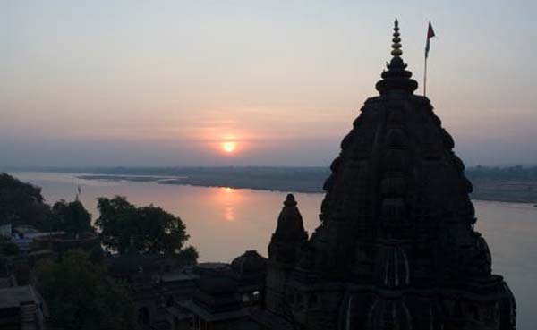
Narmada is a unique river. As the story goes, it is supposed that the Ganga comes to Narmada once a year in the form of a coal black cow, takes a dip in the Narmada River and returns as a white cow-absolved of all the sins, as they dissolve in Narmada. Well Ganga cannot sin but yes the contemporary society has certainly left no stone unturned to make it black!
Narmada, a River that even purifies the Ganga as per the mythology is an East-West flowing river. It is the largest west flowing river in the Peninsular India. Yet another unique feature of the Narmada is that it is the only river in the country that occupies a rift valley between the Vindhayn ranges on the north and Satpura ranges on the south. It flows through Madhya Pradesh, Maharashtra and Gujarat. Rising from a small tank called Narmada Kund in Amarkantak hill in Shahdol district of Madhya Pradesh.

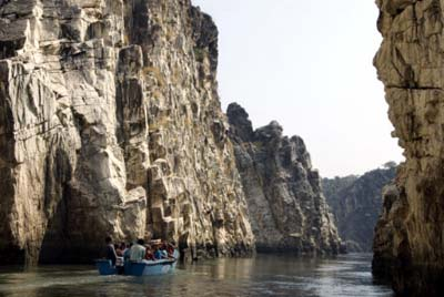
Rising from the Satpura ranges in Shahdol district of Eastern Madhya Pradesh it cuts across the hills of Shahdol, Mandla, Durg, Balaghat and Seoni in Madhya Pradesh. It is the fifth largest river in India. From a narrow marble gorge near Dhuandhar falls in Jabalpur to a broad expanse of 1.5 km near Bharuch in Gujarat, Narmada is a mighty river.
 The Narmada flows through a rift valley. These are formed due to complex natural processes leading to subsidence and uplift of the Earth’s surfaces. Starting some 250 million years ago large tracts of land in mainland Gujarat went through tectonic movements leading to formation of the rift valley presently occupied by the Narmada. The landscape in the area occupied by the Narmada in Gujarat has undergone several phases of subsidence and uplift since it was first carved out. This area is still seismically active and it has experienced some of the worst earthquakes in the pre-history, history and even during the recent times. In the past five thousand years the area has seen major upheavals. Whenever such movements which reshape the landscape occur there are readjustments of slopes and rivers either start brining more material or they change course.
The western part of the country has been a seat of tectonic activity. The course of Narmada is defined by the Son-Narmada Fault (NSF) which divides the Indian land mass in to southern peninsular block and a northern foreland block.
In the contemporary world we are much concerned about the climate change and its consequences. However, the scenario in the western part of India around 1.75 million years must have been really quite tense, because the northern foreland block of the Indian plate was under going a continuous subsidence. This must have compelled all the water to flow towards the depression that was formed. More water means more influx of sediments. Thus a thicker pile of sediments was deposited north of NSF in these 1.75 million years. The southern block on the other hand was subsiding at different rates in different parts. As a result of which the older (65 million year old) rocks had to undergo lots of stress, which is preserved even today. The twisted rocks tell a gory tale of the events they were witness to. Fortunately we were not around else there may have been spates of Copenhagen like meets!
The tectonic activity was not continuous, it took place in spurts. Thus around 85 million years ago the area witnessed uplifts again and again. Such movements within the earth brought to fore raised basalt ridges, and past river banks; there were rapid changes in the thickness of alluvium deposited and at times 1.75 million old sediments were deeply incised-developed deep chasms.
Even now the area is not very quiet, though it might appear so to a lay person. Sediments deposited in the past five thousand years show a tilting which is more pronounced in the vicinity of the NSF well above the present day tidal limits.
A river either erodes the existing surface or deposits sediments over the surface. Recent studies in some sectors of lower Narmada valley have brought to light many interesting facts. Two erosional and three depositional surfaces have been identified by Rachna Raj and M.G. Yadav of M.S. University, Baroda, Vadodara, India and Physical Research Laboratory, Ahmedabad, India. They report deposition by rivers in the Madhumati, Amravati and Kaveri river basins-all tributaries of the Narmada in Gujarat. Clays from these deposits have given ages of around 1950 to 1280 years before present.
Narmada basin has some peculiarities, normally not found in other river basins. It is tectonically active, it is dominated by southwest monsoon which often leads to storms and floods and above all the basin is earthquake prone. Historic records of earthquakes talk of quakes 500 years old. Beyond that there is no record of earthquakes. Out of these only the earthquakes which occurred during the past 200 years have been scientifically recorded and interpreted.
Archeologists have evidence to prove that Harappan cities were abandoned due to earthquakes. Also it was probably an earthquake that occurred in AD 0 at Dwarka which causes widespread liquefaction. The last catastrophic earthquake which wiped out thousands in Gujarat in 2001, caused liquefaction leading to collapse of several multistoried buildings in Ahmedabad. Such widespread earthquakes caused by plate movements within the surface of the earth cause devastation in other forms too. For example a sudden lowering of surfaces can draw more water from the higher reaches and lead to massive floods. Especially if the higher reaches also get additionally affected by heavy rainfall.
Some fine silt deposited in the lower reaches of the Narmada River hint at the possibilities of large floods around 1900 to 690 years before present. This also indicates formation of giant cesspools of water in the post flood period, in which the fine silt got deposited.
The areas where such silt is deposited are within the depositional regime of smaller tributaries of the Lower Narmada, i.e. Amravati, Kaveri and Madhumati Rivers. These rivers have small catchments and low water mass during large floods today. But the types of past deposits left by them speak something different. Small insignificant tributaries of an old river having deposits of old silt in the manner these rivers have show that the basement was undergoing a turmoil while the surface was undergoing heavy rains and floods. The first turmoil took place some 8000 years ago, followed by another some 5000 years ago and then a third one around 1200 years ago. Probably these all were devastating earthquakes.
Narmada has been shackled with Sardar Sarovar Project. A river is like a lady, she can be bound by the dams or bunds to satisfy our needs. But the day she acquires the character of a ‘Devi’ (A Goddess) she can do anything. Well this was just to emphasize the might of the River. Fact remains that the River bed is on the same surface which has been unstable in the past. One shudders to think ‘if it shakes again’! We do need power projects, we do need water to irrigate our fields and quench our thirst, but do we need such gigantic projects as we have constructed on the Narmada-on a river which is flowing through a Rift Valley?
It might be of interest to readers to know that the Narmada has been a cradle of human civilization too. Fossil skeletal remains though scanty of oldest human ancestor have been reported from a locality Hathnora on the banks of Narmada in Hoshangabad district bear testimony to this. Since there are more evidences available so far of human evolution and migration from Africa, the Narmada valley is still not considered a seat of humanity, but may be some day in the posterity more evidences come forth to prove this hunch! It is quite likely that the evidences available in the past have been wiped away by the floods that have marooned the area from time to time! Only time will tell.
24-Jan-2010
More by : V. K. Joshi (Bijji)