Dec 25, 2025
Dec 25, 2025
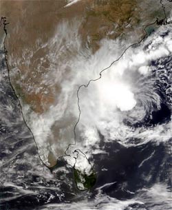
National Atlas and Thematic Maps Organization, Kolkata has prepared a map of the coastal areas that shows a 24 km wide belt all along the coast that has been identified as prone to recurrent Cyclone hazard. The belt along the east coast extends from Bangladesh to Thanjavur district in Tamilnadu and from Bhavnagar to Junagarh districts in Gujarat. On the basis of degree of cyclone damage along this belt, areas like Bhubaneshwar in Orissa, Vishakhapatnam in Andhra Pradesh, Pondicherry and Dwarka, Chittagaon in Bangladesh; Kolkata and parts of Gujarat coast fall in high damage zone. Wide tracks of lands in west Bengal, Orissa, Andhra Pradesh including Hyderabad and Mumbai fall in the category of moderate damage. Location Date Damages Kolkata October, 1737 The cyclone took a toll of 3,00,000 lives in the Ganga Delta. A 12 m high surge added to the misery. Incidentally an earthquake too coincided with the cyclone which augmented the loss of life and property. West Bengal October 1874 Vast damage to property and life took place when this cyclone killed 75,000 people and 6,000 cattle. Communication system was severely damaged. West Bengal October 1874 Perhaps October was a dreaded month that year! Another cyclone took away 80,000 human lives. Destruction of property and communication was incomprehensible. West Bengal October 1942 While the country was reeling under struggle for Independence a cyclone with a gale wind speed of 225 km per hour hit Midnapore. Andhra Pradesh November, 1946 The cyclone took a toll of 750 humans and 30,000 cattle. Roads along the coast were severely damaged. Rameswaram December, 1964 The cyclone wiped off Dhanushkodi from the map. A train was submerged in the storm surges, all passengers were wiped off and the bridge connecting Rameswaram and Mandapam islands was washed away by three to five meters high storm surges. Bangladesh November, 1970 One of the worst in recent times. Nearly 3,00,000 lives were lost. Storm surges four to five meters high ravaged the area, disrupting communication system. Tamilnadu December, 1972 80 people and 150 cattle perished. Loss of property and damage to communication network was severe. West Bengal September, 1976 10 people and 40,000 cattle killed. Immense loss of property and communication network. Andhra Pradesh November, 1977 It was a cyclone that left a trail of destruction with 10,000 human and 40,000 cattle lives lost. Road communication, power transmission lines and towers were destroyed. Tamilnadu May, 1979 700 humans and 300,000 cattle perished, communication disrupted. Orissa September, 1985 The cyclone killed 84 people and 2,600 cattle and damaged an area of 4 million hectares. Andhra Pradesh November, 1987 50 people, 25,800 cattle killed, 8,400 houses destroyed, road communication severely damaged. Orissa June, 1989 The cyclone destroyed 8,400 houses killing 50 people and 25,800 head of cattle. Communication network disrupted. Andhra Pradesh May, 1990 928 people died and 14,000 houses were damaged. Tamilnadu November, 1991 Extensive damage to roads along the coast. 185 humans and 540 cattle perished. West Bengal April, 1993 More than 100 people died, road network and other communication disrupted. West Bengal November, 1994 More than 4,000 houses damaged in 26 villages. Lakes were damaged and all communication network was severely damaged. Cyclone affected fisheries, the mainstay of local area. Andhra Pradesh October, 1996 1,057 people died, 647,000 houses damaged, road network completely damaged. Gujarat June 1998 1,261 people perished, 25,700 houses damaged. Orissa October 1999 Over 20,000 casualties, two million hectare of agriculture land severely damaged, 216,000 houses damaged, 200,000 trees uprooted and 5,200 km of coastal roads washed away. Due to an 8m high storm surge followed by incessant downpour for 48 hours, the coastal area remained submerged under three to four meter water for days together. (Adapted from India Meteorological Department reports and Gupta, M.C. et al. 2001 'Manual on Natural disaster management in India', A Government Of India Publication) When the winds are very strong houses, installations, communication system are destroyed and even trees are uprooted. The loss in terms of money is enormous. The geohazards so far dealt here through the columns of Boloji were those that originated on the earth either on the surface or from within or when the nature took its revenge by making the ocean attack the coast. There are certain natural hazards that attack the coastal areas from the skies. Amongst these, cyclone is one of the most hazardous as it can affect a large population living on the coastline. It is unfortunate that in the recent past, the cyclones have caused immense devastation on the eastern coast of the country.
Some of the deadliest cyclones are buried in the pages of history. The following table illustrates the damage by the past cyclones:
Impact on environment
Cyclones have three elements that lead to environmental degradation. These are:
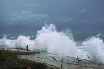
High pressure gradients of cyclones cause strong winds that generate storm surges. Sea level rises abnormally high at the coast during a storm surge and the sea water moves towards coast drowning population, live-stock, beaches and embankments are eroded, vegetation and crops are destroyed. Sudden splash on sea water on the agriculture land on the coast reduces soil fertility too.
Cyclones are also accompanied by heavy prolonged rains. This leads to floods in the rivers and low lying area though unaffected by the cyclone directly gets submerged due to floods. Coastal areas have low gradients. Water that spills over the river banks forms huge cesspools which breed mosquitoes and bacteria leading to epidemics. Thus cyclones have re-carved the landscape along the Andhra Pradesh-Orissa coast. Deltas regions of Mahanadi, Godavari and Krishna Rivers are particularly prone to more damage. This area is incidentally agriculturally rich area too. Cyclone blown sands have destroyed huge tracts of land between Machilipatnam and Machugunta. Water logging of large tracts of land too is common along this coast after the cyclones have passed off. The Orissa super-cyclone of 1999 caused a heavy and rapid silting of delta region and in estuaries, lagoons and ports too. On the other hand, the shelf region of the sea could get much lesser quantity of sand. Encrustation of salts as a consequence of evaporation of sea water from the coastal land enhances the salinity of the fertile tracts. Paradip coastal belt of Orissa during the super-cyclone of 1999 faced this problem in its severest form. Similarly in Andhra Pradesh 1.46 million hectare crop lands was covered with salt after the 1977 cyclone.
Coasts Prone to Storm Surge
Higher the intensity of the cyclone more powerful are the storm surges. High pressure gradients of the storm aided by a favorable topography of the seabed at the point where the cyclone crosses the coast decide the intensity and height of the surge.
Studies have shown that the East Indian coast along North Orissa and West Bengal; Andhra Pradesh coast between Ongole and Machilipatnam and Tamilnadu coast couth of Nagapatnam are most vulnerable areas for storm surges.
Compared to east the west coast is less vulnerable, to storm surges. However, some of the areas that have faced strong surges in the past are Maharashtra coast, north of Harnai close to Gujarat coast and the coastal belt around the Gulf of Mumbai . And also the coastal belt around the Gulf of Kutch.
Incidentally the areas most prone and prone to storm surges also happen to be some of the best developed areas. Since times immemorial despite knowing the perils, the coasts have always beckoned people. There have been ports and townships along the coasts that met a watery grave due to one or the other geohazard. Yet we prefer coasts.
We will read more in the future issues about genesis of tropical cyclones and of course how to remain safe from their wrath.
22-Apr-2007
More by : V. K. Joshi (Bijji)