Dec 24, 2025
Dec 24, 2025
The entire Himalayan belt from northwest to northeast is prone to earthquakes. Actually the Himalayas are there because of a big shaking event that rocked our sub-continent some 20 million years ago. The Himalayas were borne as a consequence of collision of two continents, the moving Indian sub-continent and the stable Asian continent. One can visualize the immediate post collision earthquakes that must have shaken our land from the fact that even today the rubbing of two continental plates shakes us from our slumber.
The Himalayan State of Uttaranchal came in to existence in November 2000. The infant state is developing fast to attain adulthood. As per the census of 2001 the population of Uttaranchal is 84.80 lakhs. Over the past decade the population has attained a growth rate of 1.9%. The State has 13 districts spread over an area of 53,119 Sq. km. Carved out of Uttar Pradesh the State has taken away 66% forests of the mother state. Along with the natural bounties, the new State has also received its share of natural disasters. Flash floods, landslides, rock fall, debris slide and the most dreaded one, the Earthquake are some of the natural hazards of Uttaranchal.
We shall turn few pages of recent history and try to examine how safe is the state for large investments from the point of view of earthquakes.
 Geological Survey of India (GSI) has carried out extensive surveys in the region and the information compiled from the data gathered over two centuries is very interesting. Thomas Oldham, the founder of GSI mentions in 1869 of an earthquake in that killed 300 people in upper reaches of Ganga at Barabal on 1st September 1803 at 0135 hrs. The earthquake is said to have damaged even the Badrinath shrine. Thereafter, the annals of the GSI are full of information on the earthquakes in Uttaranchal. On 25th May 1816 there was a major earthquake at Gangotri that caused several landslides.
 Again on 28th August 1916, and on 29th July 1980, Dharchula in Pithoragarh district was rocked, causing severe destruction of houses. The latter did not spare even the well-constructed buildings. Incidentally, Dharchula has been rocked again only a few days ago and a damage survey is being carried out.
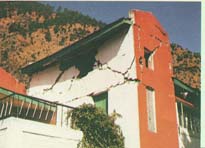
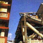
It was 20th October 1991 we were camping at Dehradun. I was busy talking with my daughter till late in the night and slept nearly at mid-night. Sleep was in its initial stages when the ground started to shake. It felt as if we were sleeping on a bed of waves. It was an earthquake, we ran out to safety. Next day we learnt that the earthquake occurred at Uttarkashi in Garhwal. It cut short the life span of 768 people, injured 5066 people and damaged nearly one hundred thousand houses located within an area of 24,000 sq km. A total of 45,765 houses were completely destroyed. The earthquake was 6.6 on Richter's scale.
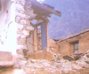
 Geological Survey Of India investigated the earthquake immediately. It was found that in the higher reaches of Bhagirathi River a 20 sq km area faced the worst wrath of the nature. Prabhas Pande an ace seismologist of GSI spoke to a survivor of a devastated village in Uttarkashi. The sobbing villager recounted, 'In the very early hours of the day we were awakened by some unknown force. The ground first heaved and then shook most violently causing collapse of our poorly constructed dwellings of mud-masonry walls and slate roof.' The story was same all over in the epicenter tract.
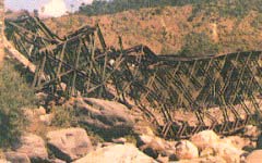
Damage was not restricted to only houses. Innumerable landslides were also generated in an area of about 2500 sq km of the Himalayan terrain. These disrupted the road communication. Telephone and electric wires were too snapped, poles uprooted along with countless trees. Post disaster mitigation process largely depends on communication facilities. A 53 meter long bridge over the Bhagirathi River too was dislodged and thrown in to the river. Thus even pedestrians could not travel to their destinations for some days
 The scars of fear of devastation of 1991 earthquake at Uttarkashi had just started to heal, when Chamoli area in Garhwal was rocked in the wee hours of 29 March, 1999. The magnitude of the earthquake can be understood from the fact that at that time many people in Lucknow were watching a late night popular Hindi movie when they felt the ground quivering. Geological Survey Of India immediately rushed a team of 33 experts to identify the affected areas and map the magnitude and intensity of the quake.
An earthquake, though a terrifying experience for the common man, offers opportunity to the geologists to unravel the mysteries of the earth's interior. Such studies help in planning for a safer future.
The survey indicated that areas covered by isoseist of IV and V were 20,900 and more than 108,000 sq km. The tremors were felt in a vast area including places like Delhi, Lucknow , Varanasi, Kanpur, Jaipur, Faridabad, Gurgaon, Ambala, Chandigarh, Ludhiana , Jammu, Srinagar , Shimla etc. As per the reports 106 people died. Maximum deaths, 63 were from reported from Chamoli. In Chamoli, Rudraprayag, Tehri and Pauri districts of Garhwal and Bageshwar district of Kumaon, 187619 houses were damaged. Fortunately infrastructure services like water, electricity and telephones were not much affected, though several landslides blocked the road.
During the past 200 years Uttaranchal has experienced 116 earthquakes. Out of these 28 were of intensity those caused havoc. The studies carried out by GSI reveal that the seismic activity is concentrated along a 50km wide belt in Bhagirathi, Mandakini and Kali river valleys. The earthquakes have cost loss of 1000 precious lives and property worth crores of Rupees.
Uttaranchal has been placed in the zone V and IV as per the Seismotectonic Atlas of India published by the GSI in the year 2000. Prabhas Pande, Director, Earthquake Geology, GSI in one of his recent papers has grouped Uttaranchal and adjoining areas of Nepal into four classes of hazard. Very High Hazard area includes parts of west Nepal and in this area the possibility of an earthquake M>6 exist every ten years. Next is the High Hazard Zone. This covers almost 36% of Uttaranchal. Major parts of Uttarkashi, Chamoli, Bageshwar, Almora, Pithoragarh and Champawat fall in this zone. Earthquakes of M>6<7 can be expected in this region every 100 years. Yet another 41% of area of Uttaranchal, including Purola, Tehri, Rudraprayag, Gairsain and Haridwar fall in the Moderate Hazard Zone. It is conjectured that an earthquake of M>5<6 can occur in these areas every 100 years. The remaining 23% of the State including Roorkee, Pauri, Nainital and Udham Singh Nagar fall in the Low Hazard Zone. The zoning is based on the available earthquake data and is open to refinement when further data is available.
How grave is the threat of high magnitude earthquake in future can be understood from the fact that Max Wyss of World Agency of Planetary Monitoring and Earthquake Reduction has also estimated that an earthquake of magnitude 8.1 can claim 96,000 to 199,000 lives and 210 to 433 thousand injured in Dehradun alone. Similar views have been aired by Prof A.S. Arya of IIT Roorkee that an earthquake of high magnitude can claim up to 100,000 to 150,000 lives.
It is clear that the State is prone to earthquakes. Safety measures need to be followed keeping in mind the possibilities of a disaster. Uttaranchal has the potential of 18,000 MW of Hydroelectric power generation. Presently only 10% of the potential is being tapped. Power generation is a major source of revenue for the State. While constructing further power generation schemes, the factor of earthquake has to be the foremost consideration.
About 22% of the population of the State lives in the six most earthquake prone districts. The Government has disaster management schemes. Unfortunately most of these schemes have arrangement for post disaster scenario. Relief after the disaster is no doubt invaluable, but a strict control over present construction activity is a must to ensure that the future generations live unscratched in earthquake safe houses. Multistoried, poorly designed and unfavorably located structures in vulnerable areas like Dharchula and Uttarkashi speak volumes about the apathy or ignorance of the authorities. The Central Building Research Institute at Roorkee has designs of safe houses to suit all types of pockets for the people of Uttaranchal.
Pre-disaster mitigation and preparedness for the disaster is vital for the safety and security of the population in disaster prone areas. The local population and the Government both should realize that a poorly designed housing complex spells doom for the residents of tomorrow. It should be noted that an earthquake itself cannot kill people, they die of roof collapse. Therefore, precautions taken now will go a long way in development of Uttaranchal.
10-Sep-2006
More by : V. K. Joshi (Bijji)

|
Thanks Manmohan. |

|
NICE ARTICLE |